LIShore photographs and maps
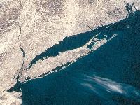 Long Island from Space. The LIShore masthead logo is
derived from this beautiful photograph of Long Island taken from the space
shuttle. We don't have complete information on the image, but it was shot in
March after a snowfall (note the ice in Great South Bay and the upper Hudson)
and appeared in the book "Orbit" published in 1996 by the National
Geographic Society. This image is cropped from the original picture supplied by
NASA through the courtesy of the Long Island newspaper
Newsday.
Long Island from Space. The LIShore masthead logo is
derived from this beautiful photograph of Long Island taken from the space
shuttle. We don't have complete information on the image, but it was shot in
March after a snowfall (note the ice in Great South Bay and the upper Hudson)
and appeared in the book "Orbit" published in 1996 by the National
Geographic Society. This image is cropped from the original picture supplied by
NASA through the courtesy of the Long Island newspaper
Newsday.
You can click on the thumbnail to load the full size image (1200 x 900 JPEG,
204 kB). Saved to your local disk and resized to fit your monitor, it makes
great wallpaper!
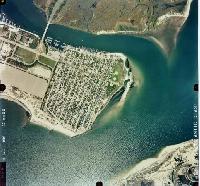
A Pictorial History of Shinnecock
Inlet.. A series of twelve annotated aerial photographs tracing the
development of Shinnecock Inlet from its formation in the Great New England
Hurricane of September1938 until today.
Map of Shinnecock Inlet and Bay instrument
locations.
 LIShore is a project of the School of Marine and Atmospheric Sciences at Stony Brook University in collaboration with the LIShore partners.
Tom Wilson (email: webmaster@lishore.org) welcomes your comments or questions regarding this web site.